geometry
Cartesian coordinate planes (Polar to cartesian)

Cartesian coordinate planes are a set of values that determine a point’s position in space. These values are often represented numerically and are based on a reference system.
Types of Coordinate Systems
1. System of Cartesian Coordinates
- consists of perpendicular axes, which in three dimensions are typically denoted by the letters x, y, and z.
- The distances that a point is from these axes characterize it.
- 2D Cartesian Coordinates: A point is represented as (x,y).
- 3D Cartesian Coordinates: A point is represented as .
2. Polar Coordinate System (2D).
- Uses a radius (𝑟) and an angle (𝜃) measured from a reference direction.
- Points are expressed as (𝑟, 𝜃) .
3. Cylindrical Coordinate System (3D)
- Combines polar coordinates in the x-y plane (𝑥−𝑦) with a height (𝑧).
- Points are expressed as (𝑟, 𝜃, 𝑧) .
4. Spherical Coordinate System (3-D)
- Uses a radius (r), polar angle (𝜙), and azimuthal angle (𝜃).
- A point is represented as (𝑟, 𝜃, 𝜙) .
What are Cartesian coordinates?
Axes
- x-axis horizontal line in 2D or a principle axis in 3D.
- y-axis: might be a vertical line in 2D or another principle axis in 3D.
- z-axis (3D): Adds depth, perpendicular to both x and y axes.
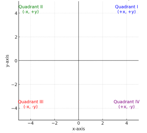
Quadrants (2D):
- The plane is divided into four regions:
- (+x,+y)
- (−x,+y)
- (−x,−y)
- (+x,−y)

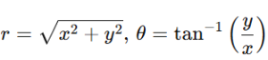
Converting Between Coordinate Systems
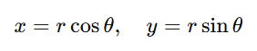
1. From Polar to Cartesian:
x=rcos(θ), y=rsin(θ)
2. From Cartesian to Polar:

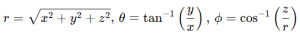
3. Between Cartesian and Spherical:

Polar to Cartesian
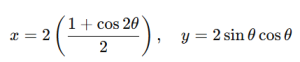
Equation: r=2cosθ
Step 1: Convert to Cartesian coordinates. We apply the following polar-to-Cartesian relationships:

Substitute r=2cosθ into these
![]()

![]()

Thus, the Cartesian form is:
![]()

Or alternatively, using the trigonometric identity:

Applications of Cartesian coordinate planes
- Maps and Navigation: GPS employs a coordinate system to find locations.
- Graphics and Animation: Coordinates describe object placements in 2D and 3D spaces.
- Physics and engineering: Explain motion, forces, and structures.
- Robotics focuses on positioning and movement planning.